
Author: Frixos Petrou, PhD Candidate and Researcher, Department of Architecture, University of Cyprus.
In the spring of 2024, I had the privilege of joining SMoG (Spatial Morphology Group) at Chalmers University of Technology. My placement centred around a design course titled “Social-Ecological Urbanism” targeted to 4th year architecture students, led by Dr. Ioanna Stavroulaki and Prof. Meta Berghauser-Pont. The course was structured around the idea that the urban environment affects social, economic and ecological processes, with the term ‘social-ecological urbanism’ being coined to describe the design approach in which these dimensions are combined. The course offered an introduction to relevant theories and concepts such as space syntax, natural movement theory, resource efficiency and sustainable development. A combination of lectures, workshops and various tools of analysis offered insights into evidence-based approaches to design and urban sustainability, focusing on balancing social and ecological aspects of design through issues of mobility, accessibility, and biodiversity preservation.
At the heart of Chalmers’ approach to urban sustainability is spatial analysis, using open-source GIS (QGIS) and the Place Syntax Toolkit (PST) developed by KTH School of Architecture, Chalmers School of Architecture (SMoG) and Spacescape AB. PST is a powerful tool to analyse different facets of the street network and how they influence people’s movement through it. Its use was implemented within the framework of the theory of natural movement (Hillier et al, 1993) in relation to urban ecosystems, density, and biodiversity. Through a series of seminars, we became familiar with Hillier’s work, focusing on his book Space is the Machine: A Configurational Theory of Architecture, examining how street networks shape movement patterns. Buildings, density and land use were examined beyond abstract metrics such as dwellings per hectare, to explore how floor area, built coverage, block structure shape spatial accessibility and social behaviours. The PST workshops running in parallel enabled us to run analyses on the street networks and densities of the existing urban fabric of Gothernburg and Norrköping, where the course’s designed projects were to be developed. Scenarios such as removing and adding bridges to Gothenburg enabled us to connect theory to practice, and led to the students being able to consider issues of spatial connectivity and density rules for the desired outcomes of their projects. These projects illuminated the practical applications of tools like QGIS and PST in crafting sustainable urban environments.
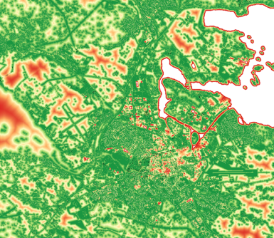
Another tool explored was HNAT, the Habitat Network Analysis Tool, another plugin for QGIS. The tool enables the analysis of species habitat networks, and facilitated the introduction of a multi-species approach and perspective to the studio’s design projects (figure 1). Lectures on designing for biodiversity highlighted key factors of urban design that would allow various species to thrive, such as ecological connectivity, green corridors, layered vegetation, blue/green infrastructures and appropriate landscape design and use of pollinator plant species. The training provided a multidisciplinary perspective ranging from network analysis to urban morphology and ecology, including guest practitioners sharing case studies from their landscape and urban design projects.
Much of the software training happened during the intensive introduction to the course. The training sessions at Chalmers’ 4-day spatial analysis laboratory enabled students to navigate the complexities of PST and carry out analyses of the Gothenburg’s street network and produce visualizations (figure 2).
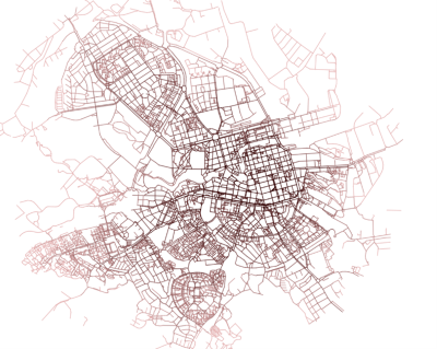
Being able to work with the developers of the PST tool was particularly interesting, as it made it easy to troubleshoot and find solutions to any technical issues. This training taught me skills that I am now applying in my PhD, for example in a recent course assignment examining sustainable mobility in the area around the University of Cyprus old campus for which I produced an analysis of closeness centrality of Nicosia at various radii in order to assess road hierarchy at the neighbourhood scale.
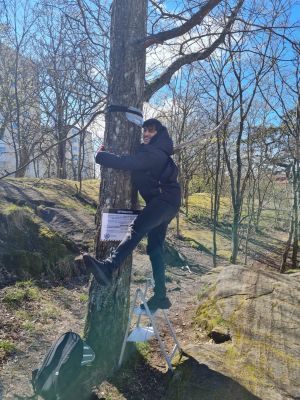
Beyond the Social-Ecological Urbanism course, I had the opportunity to immerse myself in ongoing research on urban biodiversity, led by Dr. Ahmed Hazem Eldesoky. This project focused on understanding how urban environments impact biodiversity. My involvement began with the preparation of recording devices designed to record sound, which was later processed in order to assess which species of birds were active in specific areas. The devices were placed in locations around Gothenburg (figure 3), using plastic bags to protect them from any potential rain. After a designated monitoring period we collected the devices and returned them to the lab for data retrieval and analysis.
This placement offered a unique opportunity to delve into the theory and practice of the SMoG group at Chalmers, while mastering tools like QGIS and PST, considering pertinent urban, social and ecological issues. The insights gained during my time in Gothenburg have already contributed to my ongoing academic work and will undoubtedly shape my future projects in urban planning and design, reinforcing the value of evidence-based approaches in fostering sustainable and inclusive cities.
Disclaimer: The TWIN2EXPAND Project is funded by the European Union under grant agreement 101078890 and by the UKRI under grant numbers 10052856 and 10050784. Views and opinions expressed are those of the author(s) only and do not necessarily reflect those of the European Union or the European Research Executive Agency (REA). Neither the European Union nor the granting authority can be held responsible for them.
