
Author: Walid Abdeldayem, Postdoctoral Researcher, Society and Urban Form (SURF) Research Lab, Department of Architecture, University of Cyprus.
Every street, neighbourhood, park, and public space is shaped by countless interactions between people, infrastructure, economic activity, and the natural environment. As cities continue to grow and face unprecedented challenges, from climate change and biodiversity loss to housing pressures and mobility demands, the need for planning decisions grounded in robust scientific evidence has never been greater.
Evidence-based design and planning begin with a simple principle: before we can improve cities, we must first understand how they work. This understanding does not emerge from intuition alone. Instead, it relies on developing reliable representations of urban systems, models that capture the essential characteristics of how cities function and how different phenomena interact across space.
Over the past decades, urban research has produced a wide range of analytical models designed to explain the functioning of cities. Researchers have developed methods to understand patterns of economic activity, social interaction, urban growth, environmental performance, climate adaptation, urban biodiversity, accessibility, public health, and human wellbeing. Each model provides a different lens through which urban systems can be observed and interpreted. Together, these models allow planners, researchers, and policymakers to identify where problems exist, understand why they occur, and evaluate alternative solutions before interventions are implemented.
However, no model is valuable simply because it is computationally sophisticated. A model is only useful if it represents reality with sufficient accuracy to support better decision-making. This is the central philosophy behind evidence-based planning: models must not only describe urban systems but must also be tested against observations from the real world. Scientific credibility emerges from this continuous dialogue between theoretical representation and empirical validation.
Among the many models used in urban analytics, perhaps none is more fundamental than the representation of the street network. Streets form the structural framework upon which nearly every urban activity depends. They define how people move through cities, how businesses interact with customers, how services are accessed, and how neighbourhoods connect with one another. Whether travelling by foot, bicycle, public transport, or private vehicle, movement is constrained and enabled by the configuration of the street network.
For this reason, street networks often serve as the foundational layer upon which many urban models are built. Accessibility to healthcare, schools, parks, retail centres, employment opportunities, or public transport all depend on the underlying spatial structure of streets. Likewise, urban phenomena such as pedestrian movement, economic vitality, environmental exposure, and even social interaction are strongly influenced by the way streets connect places together.
Within the SURF Laboratory, significant effort has therefore been devoted to constructing high-quality network models capable of supporting spatial evidence across multiple research domains. As part of this work, comprehensive network models were developed for two of Cyprus’ most important metropolitan areas: Nicosia and Larnaca. Rather than focusing only on administrative boundaries, the study area was defined using a territorial approach, covering a 20-kilometre buffered Urban Morphological Zone (UMZ) surrounding each city. This broader geographical extent allows analyses to capture both urban and peri-urban dynamics, recognising that daily movement patterns rarely stop at municipal borders.
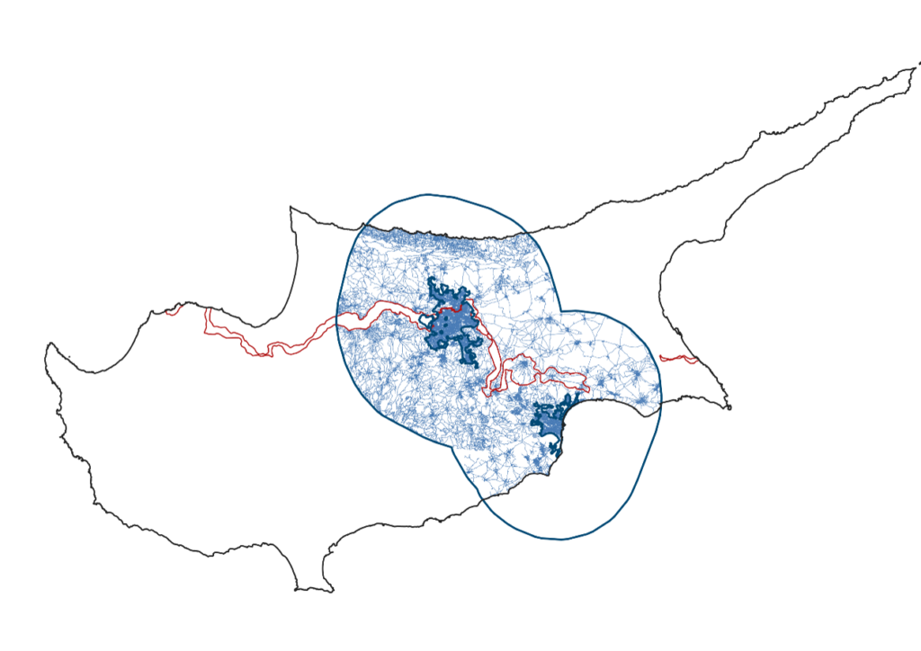
Building these network models required considerable investment in data collection, cleaning, verification, and topological correction. Although digital street data are increasingly available, transforming them into analytically reliable network representations remains a demanding task. Every intersection, connection, pathway, and street segment must accurately reflect how movement is actually possible within the urban environment. Small errors in network topology can significantly influence analytical outcomes, particularly when calculating accessibility and movement potentials across multiple spatial scales.
An important feature of the developed models is the distinction between two different movement systems: motorised and non-motorised networks. While this may appear to be a technical detail, it has substantial implications for evidence generation.
The motorised network includes all routes accessible to private vehicles and represents the structure that shapes vehicular accessibility across the metropolitan region. In contrast, the non-motorised network represents spaces that pedestrians can actually use, including streets, pathways, pedestrian links, and other walkable connections that may not be accessible by car. This distinction acknowledges that people use and experience cities differently depending on their mode of movement. A street that offers excellent accessibility for vehicles may be highly inaccessible, or even impossible, to navigate on foot.
Choosing the appropriate network therefore becomes essential for producing meaningful evidence. Analyses of walkability, public health, active mobility, retail vitality, or social interaction require pedestrian representations of urban space, while studies of traffic flows or regional accessibility depend on motorised networks. Using the wrong representation can lead to misleading conclusions and ineffective planning recommendations.
The analytical framework underpinning these models draws upon Space Syntax theory, which provides a rigorous method for representing and analysing accessible urban space. Rather than viewing streets simply as physical infrastructure, Space Syntax considers them as relational systems that afford opportunities for movement, encounter, and interaction. Through measures of spatial centrality and accessibility, it becomes possible to quantify how different locations function within the wider urban network and to understand how urban configuration influences human behaviour.
One of the strengths of Space Syntax lies in its ability to analyse spatial systems across multiple scales simultaneously. Local measures help explain neighbourhood-scale pedestrian behaviour, while global measures reveal the broader spatial organisation of metropolitan regions. This multi-scalar perspective enables planners to evaluate urban interventions not only in terms of their immediate surroundings but also in relation to the larger city-wide network.
Yet even the most theoretically robust model must ultimately demonstrate its ability to explain real-world behaviour. For this reason, the network models developed within the project were subjected to empirical validation using observed pedestrian movement data.
A comprehensive pedestrian movement survey was conducted in Nicosia to measure actual pedestrian activity. In total, pedestrian flows were recorded at 140 carefully selected locations distributed across different urban contexts. The sampling strategy intentionally captured a diverse range of morphological conditions, including city centres, residential neighbourhoods, commercial areas, and mixed-use environments. Observations were undertaken during different days of the week and at various times throughout the day to ensure that the collected data represented typical urban movement patterns rather than isolated snapshots.
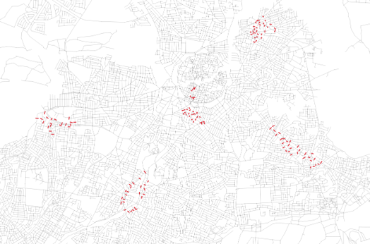
These field observations provided an independent dataset against which the analytical model could be evaluated. The recorded pedestrian counts were statistically compared with multiple spatial centrality measures derived from the pedestrian network model, particularly those representing local-scale accessibility.
The results demonstrated positive correlations between observed pedestrian movement and the calculated centrality measures, with correlation values ranging from 0.38 to 0.50 for integration and from 0.18 to 0.25 for betweenness, for the values that represent the average counting across all observed days and times. In practical terms, locations identified by the model as more spatially accessible tended to exhibit higher levels of pedestrian activity in reality. Although no urban model can perfectly predict human behaviour, given the influence of weather, socio-economic factors, cultural attitudes, land use and other variables, the findings provide strong empirical support for the ability of network configuration to explain significant variations in pedestrian movement, even in hot climates and car-dominated cities such as Nicosia.
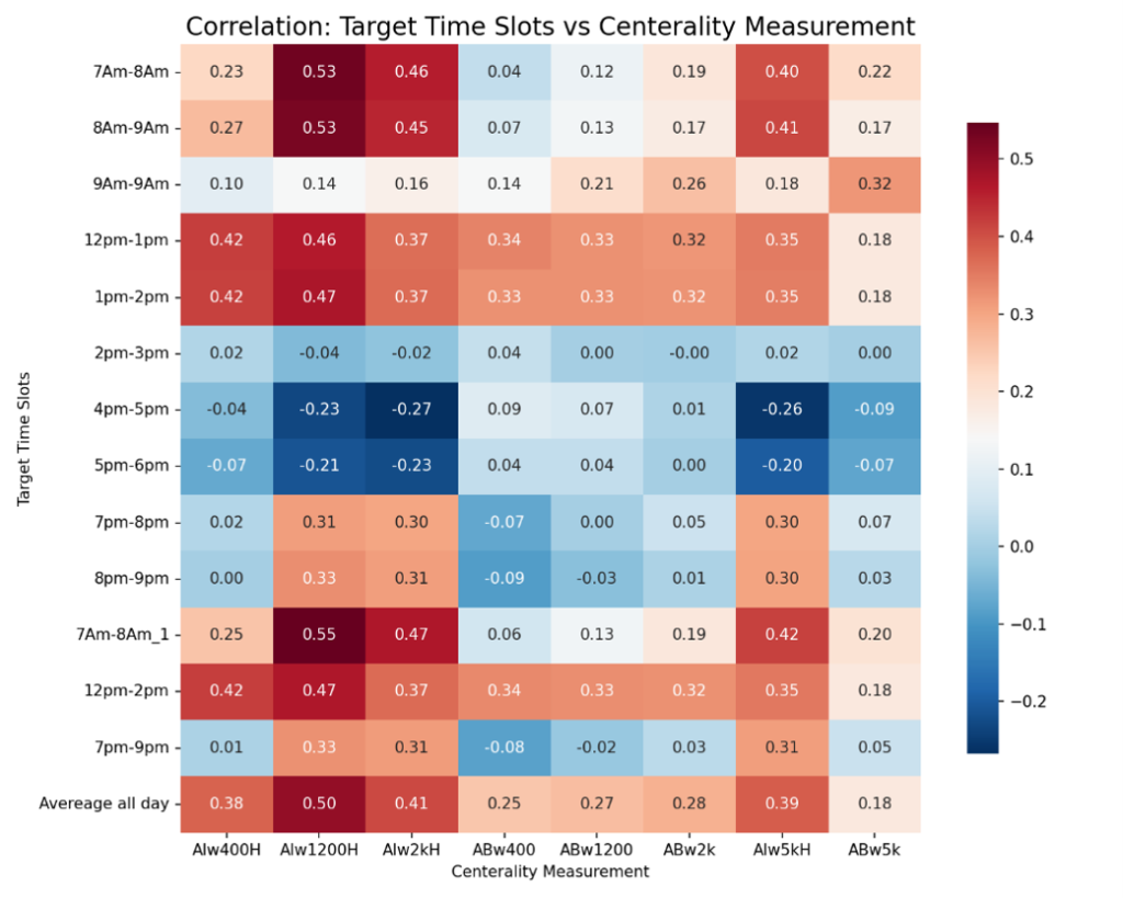
This validation process is particularly important because it strengthens confidence in both the underlying theory and its practical application. Rather than relying solely on theoretical assumptions, the models demonstrate measurable agreement with observed behaviour. Such evidence provides planners and decision-makers with greater assurance that spatial analyses derived from these models can meaningfully inform urban policy and design.
Ultimately, evidence-based planning is not about replacing professional judgement with algorithms. Instead, it is about equipping planners with scientifically validated tools that improve understanding of complex urban systems. Reliable network models allow researchers to explore scenarios, test interventions, identify opportunities, and anticipate unintended consequences before decisions are implemented on the ground.
As cities continue to evolve, the integration of robust spatial modelling with empirical validation will become increasingly important. By combining analytical methods, validated theories, and carefully collected field observations, urban researchers can generate evidence that is not only academically rigorous but also directly relevant to practice. In doing so, planning moves beyond intuition and assumption toward decisions that are transparent, measurable, and ultimately more capable of creating healthier, more accessible, and more resilient cities.
Disclaimer: The TWIN2EXPAND Project is funded by the European Union under grant agreement 101078890 and by the UKRI under grant numbers 10052856 and 10050784. Views and opinions expressed are those of the author(s) only and do not necessarily reflect those of the European Union or the European Research Executive Agency (REA). Neither the European Union nor the granting authority can be held responsible for them.
